#Writing Task 1 (Academic)
MarinaDescribing maps
Описание карты – одно из возможных заданий в IELTS Academic. Наиболее распространённые варианты:
✔️сравнить прошлое и настоящее,
✔️две карты в прошлом
✔️схема перепланировки для будущего (как на рисунке ниже)
Остановимся на самых важных моментах:
Что использовать в плане грамматики:
📍Для описания двух карт в прошлом: Present Simple /Past Simple
📍При сравнении прошлого и настоящего Present Simple /Past Simple Present Perfect (чтобы показать связь между прошлым и настоящим). Over the past 20 years, the city has become more urbanized
📍Для описания будущих изменений: Present Simple, Future Simple, выражения по типу to be planned (for), to be projected, to be expected – планируется, проектируется, ожидается и т.д.
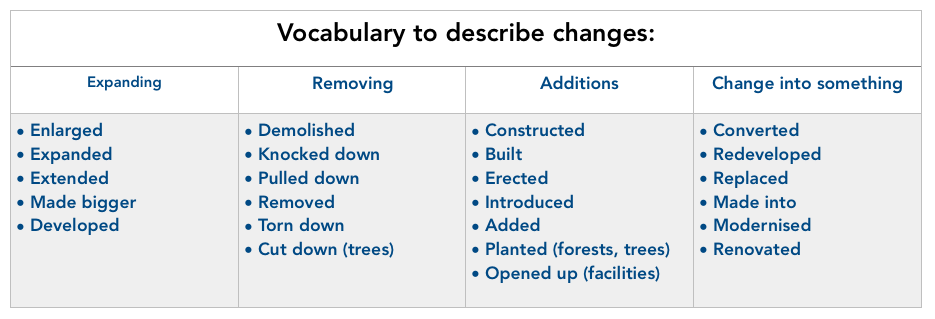
Для всех типов карт: Passive Voice в нужном грамматическом времени
new shopping mall has been built… был построен новый торговый центр…
the park was replaced with… парк был заменен на…
traffic will be diverted .. движение будет перенаправлено…
the town’s park will be reduced… городской парк будет уменьшен…
Both are connected… оба соединены…
Что использовать в плане лексики:
Over the 20-year period
In the years after 1990
over the years
in the last 5 years
to the north/east of
in the north-eastern part/zone/area
in the west and east
to the south east of
north west of
from north to south
from east to west
by
across from
nearby
between
beside
over
along
Пишем по структуре:
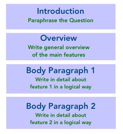
1. Перефразируем вопрос задания (1 предложение)
2. В общем два основных отличия карт (1-2 предложения)
3. Основной абзац описываем черту №1
4. Основной абзац описываем черту №2
Рассмотрим модель ответа
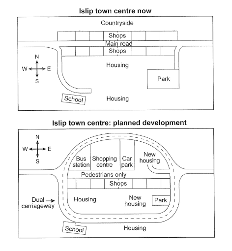
The maps below show the centre of a small town called Islip as it is now, and plans for its development. (карта см. выше)
The maps illustrate some proposed changes to the central area of the town of Islip. (перефразирование задания)
It is clear that the principal change to the town will be the construction of a ring road around the centre. Various other developments with regard to shops and housing will accompany the building of this road. (две основные черты – кольцевая дорога и строительство новых домов и магазинов)
Looking at the map of Islip as it is now, we can see that a main road runs through its centre from east to west. The second map shows the planned conversion of this street for pedestrians only. Traffic will be diverted on to a dual carriageway that will form a ring around the town centre. (более подробно черта 1)
Currently there is a row of shops along either side of the main road. However, it appears that the shops along the north side of the new pedestrian street will be demolished to make way for a bus station, shopping centre, car park and new housing area. The shops along the south side of the street will remain, but it seems that the town’s park will be reduced in size so that more new houses can be built within the ring road. (более подробно черта 2)