THE ANCIENT FORTRESS OF KAMPYRTEPA OR ALEXANDRIA OXIANA
Tourism development instituteThe fortress of Kampyrtepa is one of the oldest archaeological sites in Uzbekistan. The ruins of the ancient city of Kampyrtepa are located 30 kilometers southwest of Termez, on the right bank of the Amu Darya River, Surkhandarya region.
Kampirtepa was discovered during archeological reconnaissance in 1971 under the direction of the famous archaeologist and Academician E. V. Rtveladze and is still being investigated by him. Today, more than 70% of its territory has been studied.
In 2018, archaeologists proved that the residence of Alexander the Great was once located here, ancient Alexandria on the Oxus (the other name of the Amu Darya River), the legendary Alexandria of the Oxian, which was mentioned in his writings by the historian and geographer Ptolemy.
It was built on the edge of the right high bank of the river, cut by a network of ravines with gentle mouths and natural circuses, extremely convenient for crossing, with the creation and operation of which the history of the fortress is connected: it was located on the main road connecting the capitals of two neighboring states – Bactria and Sogda.
These are the ruins of a port city on the Amu Darya River (in ancient times Oksus), founded at the end of the IV century BC and existed until the beginning of the I century AD
The first residential buildings on Kampyrtepa were dugouts or semi-dugouts. The remains of three of them were found on the south-eastern slope of the hill. Apparently, a grandiose dugout (more than 30 m long, 4.5 m deep, 7-10 m wide) excavated on the eastern hill of Kampyrtepa belongs to the same period, which, according to the author of the excavations, N. D. Dvurechenskaya, can be interpreted as a "dugout" – a temporary dwelling of a small garrison.
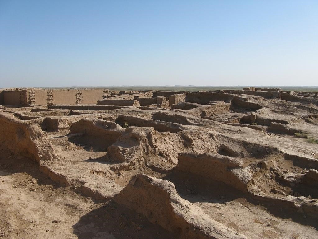
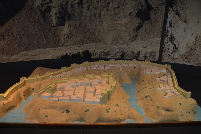
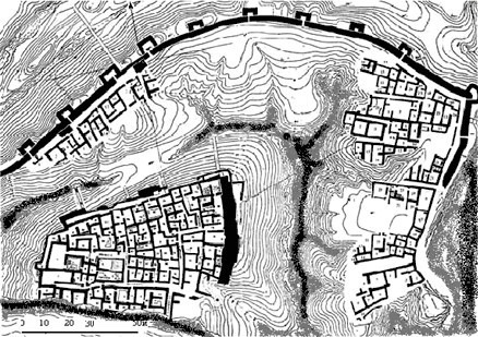
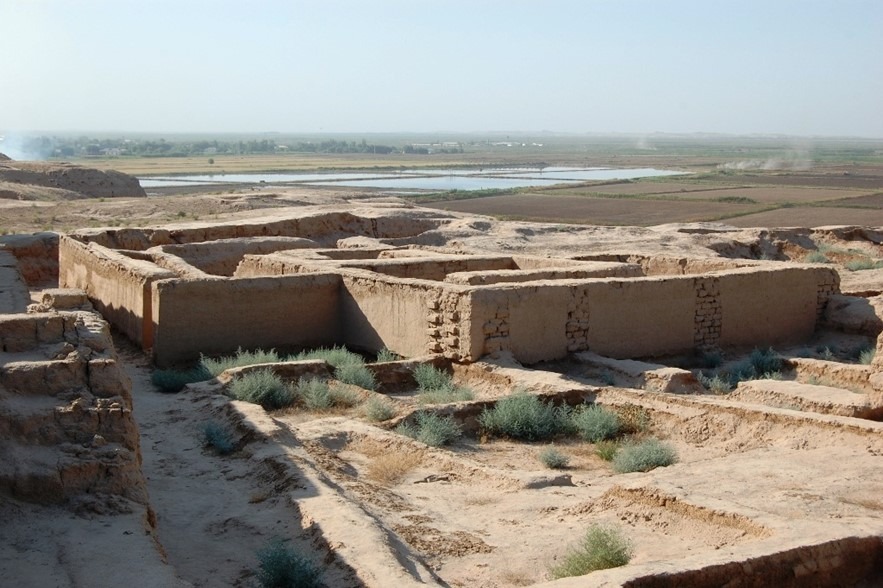
The Kampyrtepa complex consists of a main citadel, surrounded by a moat, “downtown”, walled by a rampart with towers, and unfortified suburb. There, the archaeologists found well-preserved cultural layers of early Hellenistic, Greco-Bactrian and Kushan-Uezhian eras. We studied a continuous development divided by narrow alleys – small two-and four-room buildings that stood close to each other. The settlement includes a powerful citadel of square shape, 80*80 meters, a residential part and an undefended "suburb". It includes more than 100 different rooms.
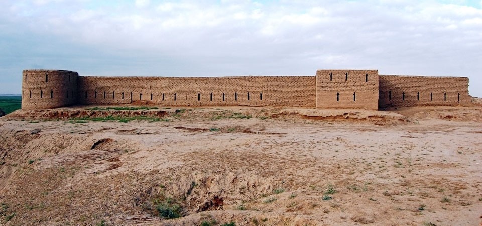
The most powerful fortifications on the coast of the Amu Darya and in Central Asia were identified, as well as residential and, possibly, port buildings, built of raw bricks of the transition from the Achaemenid to Hellenic standard, pottery workshops, firing ceramic and other furnaces. There are many meters of cultural layers with materials, ceramics and other products of the post-Achaemenid, Hellenistic and Greco-Bactrian times. By the way, they discovered not only on the territory of the original fortress, converted at that time to the citadel, but in the moat around it, located in the floodplain of the city (almost fully washed away, like the half arch of the citadel), and also in the suburbs and on-site Marina. These buildings and layers of habitation occupied a very large area. The design and structure, construction techniques and standards, the power and grandeur of its fortifications clearly confirm that the builders of the fortress embodied the idea of the architects who followed the Hellenistic traditions and instructions of either Alexander the Great himself (329-323 BC), or the governors who inherited Bactria in the "troubled" period (from 323 to 306 BC) that followed after his death.
The arch-citadel is located in the central part of the castle, part of which is washed away by water from the south. It had an area of 1.3 hectares and a gate in the south-eastern corner. The citadel was surrounded by a massive brick wall. The wall is surrounded by a trench 10 meters wide. Inside the citadel there are rooms for various purposes, which form 4 large blocks connected by corridors. The undefended part of the fortress of Kampyrtepa is mainly occupied by a complex of burial structures. In the north-western part, on the area of 0.5 hectares, there are 10 graves of the naus type, built of square-shaped mud bricks 33-35 * 33-35 * 13-14 see In the eastern part there is another burial structure, the shape of which is rectangular, extending from north to south and long. 66.5 m, width 3-4. 2 meters and consists of three buildings separated by corridors, the vessels were found In this part of Kampyrtepa.
The strengthening of this section was due to the presence of one of the roads passing through the Amu Darya. There was a place for traders, taking the route of the Silk Road, where they could rest, dispatch their goods and customs duties could also be paid. The fact that around 1,000 bronze coins were found in such a small castle is evidence of vital financial and economic activity. During the study, it was possible to determine the chronology of the monument.
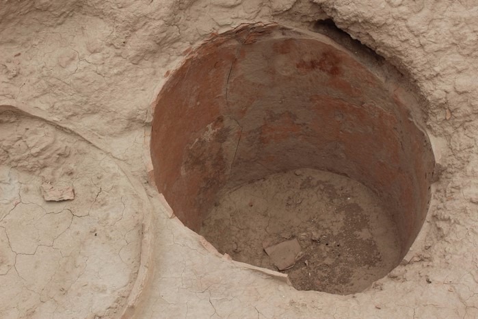
According to researches was revealed three historical periods of formation Kampyrtepa. In the first period (III-II centuries BC) - there was already a trading post - "transshipment base", where goods were concentrated before being sent to the left bank of the Amu Darya or waiting for a caravan to the north, towards Sogd. This is evidenced by the fact that one of the dugouts, in fact, was a storage-humkhona, perhaps not the only one in the settlement. One of the hums found in the dugout was sealed. The impression of the gem was not on the vessel, but on the clay with which the lid was smeared, that is, the contents of the huma were sealed. Thus, it was a temporary storage facility for some bulk or liquid product, sealed by the owner when the product was purchased and stored on Kampyrtepa before being sent to its destination. Another explanation is also possible; the goods were delivered to Kampyrtepa as an intermediate point on the route, sealed and deposited for a certain period of time until they were re-purchased and sent to the new owner.
A time of occurrence of fortress on the place of the future arch. Most of the settlements of the Greco-Bactrian period were washed away by the Amu Darya.
In the second period (II-I centuries BC) - on the place where the Arch was located, life partially revived. Square Kampyrtepa expanding. At the same stage, pottery production begins to function on the territory of the settlement and next to it. On the territory of two open courtyards there is a large production center, which worked throughout the second stage of the monument's life. On the territory of the citadel, 7 firing devices of the original design are opened. In the same period, the pottery workshop in the vicinity of the settlement to the east of the citadel continues to function. Apparently, the ceramics were only fired here, and the vessels were made in another place, maybe in residential premises. This, in particular, is indirectly evidenced by the findings of fragments of unburned, but dried ceramics in the premises of the complex.
The third period (I-II centuries AD) – the period of intensive construction and formation of powerful fortress. The city reached heights in its development in the reign of Kanishka I (the first third of the II century AD). This era was characterized by the most favorable conditions for the development of international trade and culture. The buildings of the third period of the existence of Kampyrtepa within the limits of the excavation in the South-Eastern part of the citadel was not detected. At the same time, life on Kampyrtepa certainly continued. The most numerous archaeological finds belong to the Kushan period. Thus, a Buddhist sanctuary, built outside of the vallum, as a tribute to a Greco-Bactrian tradition, was found there. At the same time, the architecture of the sanctuary belongs to the Zoroastrian era. A terracotta figure of seated Buddha, found in its base, embodies simultaneously the features of Buddha and Ahura Mazda, the deities of Zoroastrianism and Buddhism, the religions, ruling at the time.
Numerous finds, as well as features of the architecture of the settlement, indicate that various cults and religions have peacefully coexisted in Kampyrtepe for centuries. Zoroastrians, Buddhists and worshippers of ancient Greek gods, as well as followers of local cults, got along here. Archeological excavations except for set monetary treasures revealed the monuments of five scripts- Greek, Bactrian, Brahma, Kharosthi and unknown letter.
Among the materials obtained during the excavations at this monument, there are many unique ones – a round disc-shaped ceramic seal, the first in the territory of Bactria with a Parthian inscription. On its front side is scratched the name Naban or Nabun, similar to the Babylonian Nabonidus. It is written in Parthian or Aramaic script. On the back is an inscription that probably conveys the title of the position.
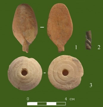
A true masterpiece of ancient art and ivory carving is the style for writing (I-II centuries AD) with a pommel in the form of a figure of a woman. All the details of the terrain are carefully worked out. The facial features are pretty. Parthian hair style: tied with a tiara and tied in a knot above the head. The iconography of the plot is unique and so far has no analogues among similar products found in Central Asia, and is not typical for them.
They found a bone hairpin with a broken top and tip (preserved length of 9.3 cm), a fragment of a shell flap, fragments of easel and stucco ceramics, as well as a terracotta horse with a broken muzzle; the figure of a rider was not preserved, spoons, a spinning wheel. Among the ceramics, there are fragments of khums with signs: a swastika and, apparently, a W-shaped tamga.
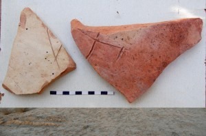
Archaeological excavations have revealed many domestic ceramics, terracotta figures and statues, jewelry and much more, which formed the basis of many historical and archaeological museums.
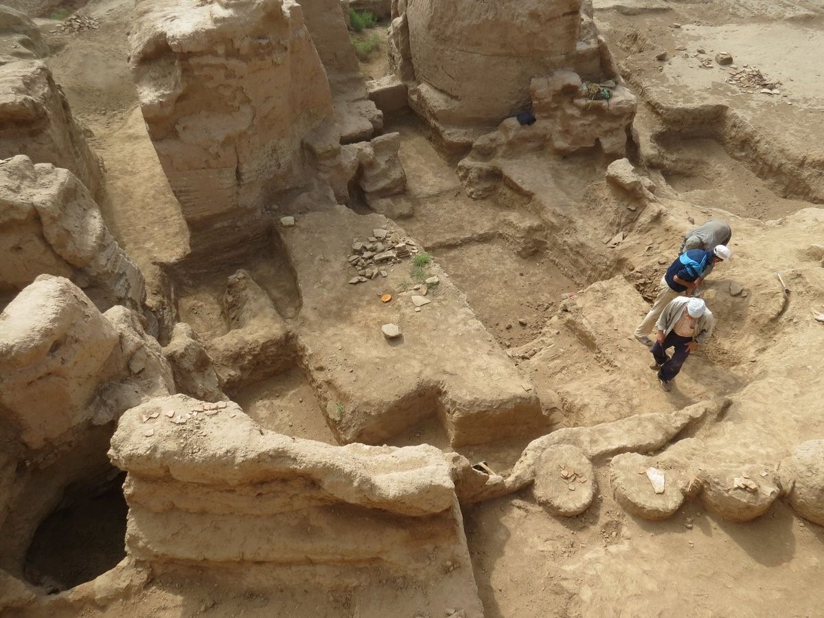
The restoration of part of the outer fortress wall and one Kushan quarter was carried out with the maximum use of ancient construction techniques. For the formation of raw bricks, loess was used, which was taken at the foot of the fortress wall, dried on the spot and laid on a clay solution.
Kampyrtepa is one of the iconic landmarks of Surkhandarya oasis included in the UNESCO World Heritage List.
METHODOLOGICAL RECOMMENDATIONS:
1. The guide have to be very-well informed and be well-versed in this archaeological site.
2. It is necessary to have a plan, diagrams and photos to demonstrate the additional visual range.
3. Highly recommend to inform the group about the weather conditions and to use a comfortable shoes, as well as umbrellas in the hot or rainy season.
4. The work of the guide consists of 45 minutes of excursion time.
5. Tourists are given at least 20 minutes for independent inspection and photography.
Compiled by: R. Nuralieva, a guide of the first category.
Translated by: Azarenko E., a guide of the first category.
Tourism development institute under the State Committee of the Republic of Uzbekistan for Tourism Development
👉 Join it: https://t.me/guide_portfolio