Chapter 2: Site Investigation (BGN254) / Chapter 3: Site Investigation (DCT400)
Mohamad Ezad Hafez Mohd Pahroraji- Statistics shows that 80% of problems encountered on construction projects are due to unforeseen ground conditions that could have been avoided if a suitable site investigation was carried out.
- Unfortunately, soils are made by nature and not by man, and the products of nature are always complex. (Karl von Terzaghi, 1936)
Content of the Chapter
1) Importance and Objective
2) Types of Site Investigation
3) Methods of Site Investigation
4) Factors/Elements to be investigated
Introduction
- Site Investigation is the process of collecting information, assessment of the data and reporting potential hazards beneath a site which are unknown.
- Site investigation is the process by which geological, geotechnical, and other relevant information which might affect the construction or performance of a civil engineering or building project is acquired.
- Site investigation is an evaluation process on the factors effecting the selection and usage of site.
- Execute at the pre-construction stage.

- Site Investigation usually limited to the proposed construction site only, but in some circumstances it needs to be done at the surrounding area which have an existing buildings/structures nearby.
- It is important to obtain previous site investigation records as a reference and comparison during the investigation.
- Types of information needed may be vary, depends on type of project and soil condition.
- Site investigations should include:
1) Susceptibility to groundwater levels and flow.
2) Underlying geology, and ground.
3) Identification of physical hazards.
4) Identification of methane and other gases.
5) Determining an appropriate design.
6) Providing soil parameters for design and construction.
- The approach to be adopted for a particular site investigation, its extent and the techniques used will all depend upon the site-specific circumstances, and the experience and judgement of those involved.
The Importance
Why Site Investigation is important? because of the following reasons:
- To allow the determination of the following factors by the designers (architect & structural engineer) and contractor :
1) The actual condition on site.
2) Any possibility/problem that may occur/face in future.
3) To ensure good and economic structures are built.
4) To ensure the safety of the building for tenants / public.
- To ensure the types of building / the construction project suit with the site (condition & positioned), by considering the following factors:
1) Existing public facilities - road, transportation facilities for access, water supply, power and telecommunications, sewerage and drainage
2) Existing Neighborhood - existing structure adjacent/adjoining to the site
3) Historical Factors - previous building works, mining, obstruction, contamination
4) Environment - local condition, resources (natural, infrastructure), availability of a suitable workforce, disposal of wastes, living amenities (accommodation).
- Inadequate site investigations may lead to:
1) The wrong choice of design.
2) Incorrect dimensioning.
3) Inadequate foundation solution.
4) Encroachment on neighbouring properties or easements (road reserves, pipelines, overhead supply lines).
5) Ill-judged or dangerous execution of ground construction work as well as damage to neighbouring buildings or other structures.
6) The economic cost can be enormous. Can result in Variation Order (V.O) such as addition or omission of work.

The Objectives
- The objective of a site investigation is to gather the information needed to carry out the risk assessment.
- The number one objective of a site investigation is to determine as accurately as may required:
1) The nature and sequence of strata (layers of soil/rock).
2) The ground water conditions at the site.
3) The physical properties of soil and rock underlying the site.
4) The mechanical properties such as strength of different soil or rock strata.
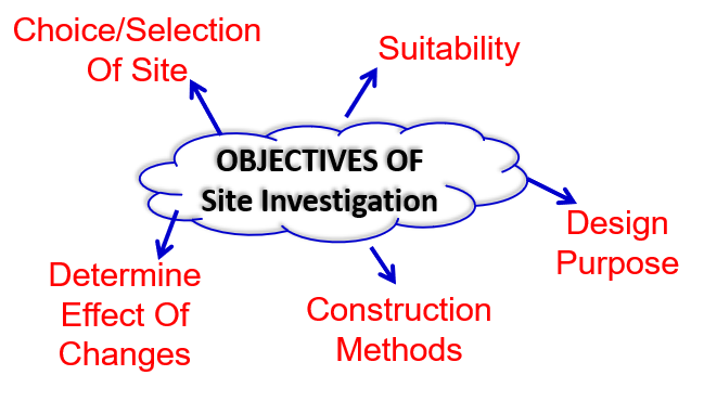
1) Suitability
- To assess the general suitability of the site and the environment for the proposed works including implications of previous use or contamination.
2) Choice/selection of site
- Where alternatives exist, to advise on the relative suitability of different sites or different parts of the same site.
3) Design purpose
- To enable adequate and economic design.
- To be prepared, including the design of temporary works.
4) Construction methods
- To plan the best method of construction.
- to foresee and provide detail on difficulties and delays that may arise during construction due to ground and other local conditions.
5) Determine effects or changes
- To determine the changes that may arise in the ground and environmental conditions, either naturally or as a result of the works and the effect of such changes on the work, on adjacent works, and on the environment in general.
Types of Site Investigation
1) Investigation For New Works
2) Investigation On Defects or Failures of Existing Works
3) Investigation On Safety Of Existing Works
4) Investigation On Material Constructional Works
1) Investigation For New Works
- To obtain actual information on site condition (topography, types of soil, strata, capacity to gain soil load, underground water level e.t.c) to come out with suitable, safe and economical design.
- To full fill tender’s requirement.
2) Investigation on Defects or Failures of Existing Works
- To investigate previous defects/failures occurred on existing building.
- It is Important to know what are the reasons of failures for better precaution and improvement in future.
3) Investigation on Safety of Existing Works
- To ensure the new construction work is safe and will not effect the nearest existing buildings/structures, workers and publics.
- Factors affecting the safety measures:
i. Building/Structure Load - fracture, deformation, fatigue.
ii. Soil Excavation - collapse that can trap or crush worker.
iii. Vibration causes by driven piling - like dynamite blast/nuclear blast/sonic boom, is a source of vibration cause damage to structure.
iv. Underground water - water leak, wet basement, mold growth.
4) Investigation on Material for Constructional Works
- To estimate the suitability and quantity of materials that can be obtained from excavation works ( whether it can be replace/import/reclaim at other places).
- To source materials that suitable for certain purpose. (aggregates for concrete and road works, etc)
- To find out suitable area/site to dispose material waste.
Methods of Investigation
- There is no single way to carry out a site investigation and inevitably different approaches will be adopted for any particular development. The process of collection of information, appraisal of data, assessment and reporting will most likely be staged. The various stages for a site investigation include:
(some methods applied at the same time / not necessary)
1) Planning
- Setting clear objectives for the site investigation, including scope and requirements, which enable it to be planned and carried out efficiently and provide the required information.
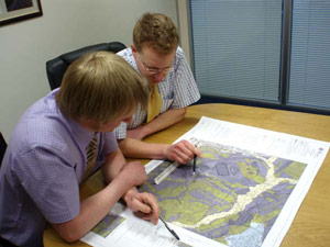
2) Desk Study
- A desk study is the collation and review of information already available about a site, and is carried out at an early stage of site appraisal to inform and guide the remainder of the site investigation.
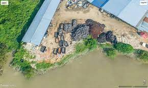
- Why commision Desk Study? The historical use of land can have an impact on its future use. Reviewing historical, geological and environmental information about the site. A desktop study is one of the most valuable and cost-effective elements of a site investigation. At this stage the site is not visually appraised but a search is instigated for any information concerning the site, such as its environmental constraints, land resources, any previous investigations, former uses, any history of performance and any features in the area which may have influenced the site or which the proposed development may influence.
- Information may be obtained from various sources such as maps and published documents, aerial imagery e.g. aerial photos, Google Earth, survey plans, state planning policy searches, online resources and from interviews and contacts. In this stage, a preliminary assessment of the site’s suitability can be assessed. For example, details about past and present land use, natural resources, geology, surface and groundwater environment, cultural heritage, archaeological values, contaminated land status and land use restrictions that may be relevant to the proposed development can be taken into account for future planning of the project. Several sites can be evaluated in this way at minimal cost.
- What is included within Desk Study Report? Instant access to datasets relating to contamination characteristics of land; past and present. In-house database provides a valuable source of information with respect to anticipated ground conditions and potential geological or engineering issues. In depth enquiries to the Environment Agency, Local Authority, or local study libraries.
- Data for a desk study can also be obtained from sources such as:
1) Local municipalities.
2) Libraries.
3) District offices.
4) Survey offices.
5) Utility and service providers.
6) Commercial databases through the internet.
- Geological maps, old plans and photographs can be obtained from the survey and records department.
- A desk study includes:
1) Landfills.
2) Waste disposal sites.
3) History, if any, of hazardous incidents.
4) Quality of surface water and groundwater vulnerability.
5) Past local borehole records.
6) Presence of mines.
7) Historical mapping.
8) Buried and overhead supply and utility lines.
3) Site Reconnaissance (Tinjauan)
- Reconnaissance is an integral part of site investigation and is carried out at the preliminary stage before other stages are begun. Reconnaissance involves a field trip to the site where further investigation is to be carried out. It gives details of landforms and other structures that are above ground which may form an obstacle for an installation.

- Reconnaissance survey also involves studying existing survey maps and contour maps. These can be used to mark out natural formations such as hillocks, utility structures and other sub-surface structures that have been surveyed before.
- Simply scouting around the site can sometimes provide a lot of information such as topography, vegetation, geological features and utility lines.
- Observations made during site reconnaissance include:
1) The topography of the land including water bodies, estuaries, reserved land and quarries.
2) Slopes angles and orientation.
3) Presence of structures, heritage structures, trees, and utility lines.
4) Presence of hazardous industries or waste disposal sites that could be a potential public health hazard.
5) Areas with loose soil, patches of soil discoloration, excess growth of vegetation or foul smell.
6) Comparison of the previous plans with current situation i.e. addition of new structures or utility lines.
- Site reconnaissance (a walkover survey): Identifying actual and potential hazards and the design of the main investigation. In this stage, visual inspection of the site is done and information about topographical and geological features of the site are collected. The general observations made in site reconnaissance are as follows :
- Presence of drainage ditches (longkang) and dumping yards etc.
- Location of groundwater table by observing well in that site.
- Presence of springs, swamps, etc.
- High flood level marks on the bridges, high rise buildings, etc. are observed.
- Presence of vegetation and nature of the soil.
- Past records of landslides, floods, shrinkage cracks, etc. of that region.
- Study of aerial photographs of the site, blueprints of present buildings, geological maps, etc.
- Observation of deep cuts to know about the stratification of soils.
- Observation of Settlement cracks of existing structures.
4) Detail Examination and Special Studies
- Consist of site exploration & sampling, field test/in-situ test, laboratory testing and report writing.
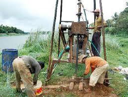
- Based on the above study, locations for trial pits and boreholes can be selected. The selection should be such that a complete geologic sub-surface perspective can be obtained. At least three points should be selected with spacing of 10 to 30 meters depending on site conditions and type of project. Commonly boreholes, probes and trial pits are used to undertake in-depth investigation.
- Main investigation and reporting: Including intrusive and non-intrusive sampling and testing to provide soil parameters for design and construction. After performing detailed site exploration methods a report should be prepared. A sub-soil investigation or exploration report generally has the following sections :
1) Introduction.
2) Scope of site investigation.
3) Description of the proposed structure, purpose of site investigation.
4) Site reconnaissance details.
5) Site exploration details such as number, location and depth of boreholes, sampling details etc.
6) Methods performed in site exploration and their results.
7) Laboratory tests performed and their results.
8) Details of Groundwater table level and position.
9) Recommended improvement methods if needed.
10) Recommended types of foundations, structural details, etc.
11) Conclusion.
5) Review During Construction And Monitoring
- In general, known landslides that are a risk to public infrastructure, private property, and personal safety should be monitored in order to minimize the potential risk.
- The monitoring program, whether it is simple or complex, must be designed based on the geological, physical, and environmental conditions of both the landslide hazard and the elements at risk.
- There are two paramount reasons for monitoring landslides:
1) To understand the dynamics of the mass movement to facilitate the assessment of the hazard;
2) To assess the degree of instability through detection of changes which enable the development of accurate early warning systems and precautionary measures.
- Monitoring methods for slope instability include a wide variety of instruments and techniques.
- Commonly slopes are monitored for displacement, differential movement, hydrological changes, strain, and ground temperature, whereas the physical environment is monitored for temperature and precipitation.
Factors to be Investigated
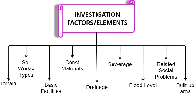
1) Terrain (Bentuk Muka Bumi)
- To obtain an overall figure on the infrastructure works that need to be prepare before the construction works commence on site .
- Terrain of the site can be defined either:
a) Flat 0%-3% gradien
b) Undulating 3%-25% gradien
c) Hilly > 25% gradien
d) Swampy
e) Built up area
f) Developed area
- Sometimes the terrain of the site also can be described based on the following factors: - any plants/trees? River crossing? Rocks? Water level? Types of existing building nearby? Access road? etc
2) Soil: Types / Works
- Before deciding any extra soil works to be done (before construction), it is important to determine the type of soil on the proposed site. (sandy, rock, swampy, abandoned mining, or clay/silt).
- Example of consideration need to be taken:
1) Big project @ wide area: Need to refer to specialist & Geologist
2) Rock layers: Problems in excavation works need blasting works (extra time & cost)
3) Abandon mining: need extra soil improvement works
4) Groundwater table.
5) Natural gas underground.
3) Basic Facilities
- Access Road
- Is it available? Or need to construct temporary road to site?
- Types of road: paver or laterite??
- Factors need to be measured to estimate an overall cost for road works:
1) Length/Distance to the nearest main road available
2) Types of road
3) Width & Design
4) Types and source of materials
- Water supply??
- Example: in developed area, water supply is readily available (JBA/JKR). Thus it can be tapped on to the site from the existing main pipe provided.
- However need to check the current capacity and water pressure.
- If the current supply is inadequate for the new area, new water supply layout pipe need to be design (together with a new cost).E.g: rural area, temporary source:river / hill area.
- Electricity supply??
- require generator set as temporary supply? Or new substation?
- Telephone @ communication?? Signal? require satellite phone?
- Existing underground services? gas pipe?
- Relocation of utilities?
4) Construction Materials
- Availability of source?? Especially main materials used; sand, aggregates, cement, bricks, premix, special item, etc.
- Determination on source, cost n supplier / method to supply those materials to site.
- Transportation? Construction on island? Rural area?
5) Drainage
- To determine on how to flow water off site.
- Is there any existing drain or earth drain nearby??
- Surface water should not flow through the selected site.
6) Sewerage
- Need to decide wether to provide connection to the Central Sewerage System or to built temporary septic tank / sewage treatment plant purposely for the construction use.
7) Flood Level
- Flood prone area such as at the East Coast area.
- May involve extra works: reclamation, fill up area.
- Flood level: “Jabatan Pengairan dan saliran”.
8) Related Social Problems
- Example in K.L area: squatters problem due to boundary/right of way. Provide new home?
- Rural: Protest development on their area. Political influences?
- Land Acquisition required? Compensation?
- Tanaman Kontan?
- Right of Way (R.O.W), require adjustment of alignment? Kilang Haram?
- Abandon old structures?