A Look at History of DPR, LPR, Kherson & Zaporozhye Regions
Sputnik International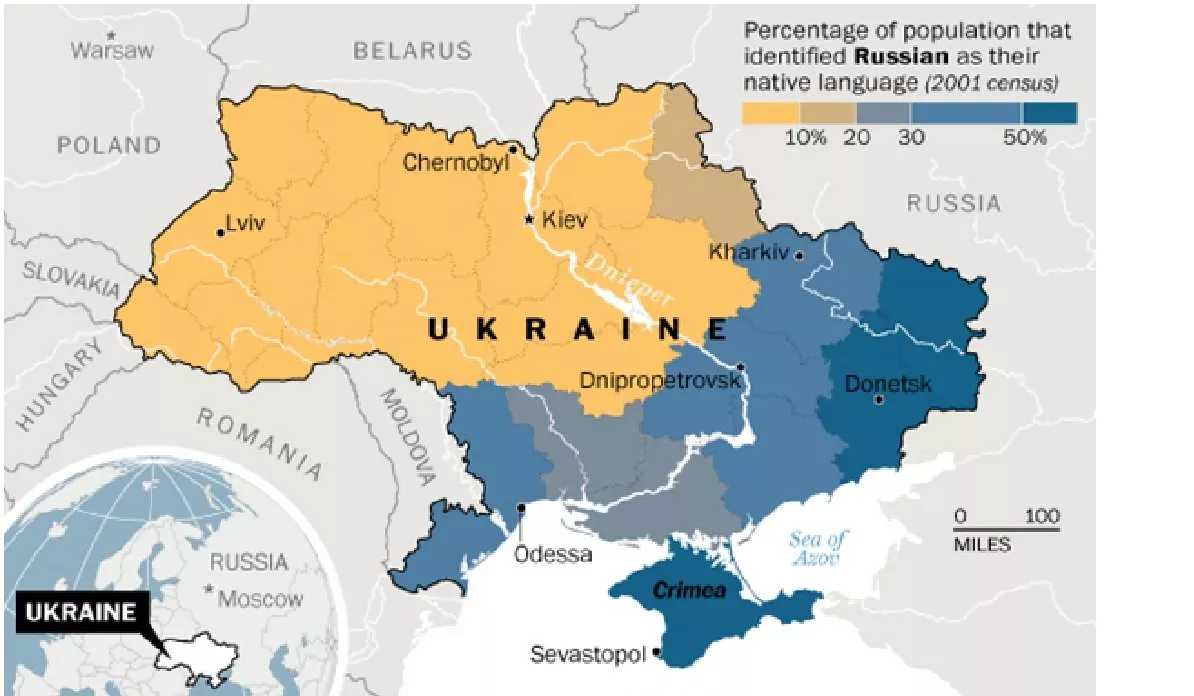
The Donetsk and Lugansk People’s Republics, which proclaimed their independence from Ukraine in 2014, announced their plans to hold referendums to join Russia on September 19. The administrations of the Russian-controlled parts of Kherson and Zaporozhye regions announced similar plans the following day.
Referendums on accession to Russia in the Donetsk and Lugansk People’s Republics (DPR and LPR), as well as Russian-controlled parts of the regions of Kherson and Zaporozhye are to run from 23 to 27 September.
On February 21, Russia recognized the DPR and LPR as independent states. Russian president Vladimir Putin announced the start of a special military operation in Ukraine on February 24 in response to calls for help from the two breakaway republics, whose predominantly Russian-speaking population faced intensifying attacks on the part of Kiev. The nationalist regime that came to power on the back of a West-backed coup in 2014 had killed thousands of civilians over the course of eight years, with all attempts to resolve the conflict peacefully, promoted by Russia, foiled by Ukrainian officials.
In the course of the operation, significant areas of the DPR and the entire territory of the LPR were liberated. Russian forces also took control of the Kherson region and the Azov part of the Zaporozhye region, with new administrations formed in both regions. Since then, Russian TV channels and radio stations have begun broadcasting there, and trade and transport links with Crimea are being restored.
The DPR and LPR announced their plans on September 20 to simultaneously hold referendums to join Russia following the respective requests from their Civil Councils. The Russian-controlled parts of the regions of Zaporozhye and Kherson also announced plans for holding similar referendums, hoping that the initiative would result in securing the territories of the region, opening “new opportunities for a return to a full-fledged peaceful life.”
According to Volodymyr Rogov, a member of the civic council of the Zaporozhye region, the area of the liberated territories where the referendums will be held is about 113,000 square kilometers. After the accession referendums held by the LPR, DPR, Kherson and Zaporozhye regions, the population of Russia could potentially increase by five to six million people.
Here is a detailed look at the areas, which are determining their future.
Donetsk People’s Republic (DNR)
The Donetsk People's Republic (within the borders of the Donetsk region) is situated in the south of the East European Plain. Washed by the Sea of Azov from the south, it borders on Ukraine (Dnipropetrovsk, Zaporozhye and Kharkov regions), Russia and the Lugansk People's Republic.
The area of the territory (within the borders of the Donetsk region) is 26.5 thousand square kilometers. According to the Main Department of Statistics of the DPR, as of March 1, 2022, the population is estimated to be about 2.198 million people. The DPR is a presidential republic, with Donetsk, Makeevka, Gorlovka its three largest cities.
The city of Donetsk grew from a mining settlement in the early 1860s. It received city status in May 1917, and at the end of that year, Soviet power was established in the city during the revolution.
From January / February - March 1918, Donetsk was part of the Donetsk-Krivoy Rog Soviet Republic within the Russian Soviet Federative Socialist Republic (RSFSR). At the second All-Ukrainian Congress of Soviets on March 17-19, 1918, it was incorporated within the Ukrainian Soviet Republic. After the signing of the Brest-Litovsk Treaty on March 3, 1918, between the new Bolshevik government of Russia and the Central Powers (German Empire, Austria-Hungary, Bulgaria, and the Ottoman Empire), that ended Russia's participation in World War I, Donetsk was occupied by German troops at the end of April 1918. Until the end of 1918 the city remained part of the Ukrainian state of Hetman Pavlo Skoropadsky. In December 1919, during an offensive launched by the Red Army, Soviet power was restored in Donetsk.
From the end of the 19th century, the region experienced an industrial boom, with metallurgical and machine-building plants, railways, and mines built. On July 2, 1932, the Donetsk region was formed as part of the Ukrainian SSR. On June 3, 1938, it was split into the Stalin and Voroshilovgrad (now Lugansk) regions.
During World War II (The Great Patriotic War), on October 20, 1941, Donetsk was occupied by German troops. 92,000 people are estimated to have died in the three concentration camps set up by the fascists in the city and surrounding areas. On September 8, 1943, Donetsk was liberated by Soviet troops during the Donbass offensive operation.
After the collapse of the USSR in 1991, the territory that is now the Donetsk People’s Republic found itself a part of Ukraine.
However, in 2014, protests began to erupt in the southeastern regions as people became increasingly dissatisfied with the new leadership of Ukraine, after then-President Viktor Yanukovych was overthrown in a coup d'etat orchestrated by Washington and Brussels, giving rise to the Ukrainian crisis and sparking a civil war in Donbass.
On April 13, 2014, Acting President of Ukraine Oleksandr Turchynov announced a "large-scale anti-terrorist operation" involving the army against the predominantly Russian-speaking south-eastern regions.
On May 11, 2014, a referendum on self-determination was held in the Donetsk region amid fears that new nationalist politicians would infringe on their rights to freely use the Russian language. On May 12, on the basis of the declaration of sovereignty of April 7, DPR proclaimed its independence. Besides Russia, the independence of the DPR was recognized by the Lugansk People's Republic, the Republic of Abkhazia, the Republic of South Ossetia, North Korea and Syria.
Since February 24, 2022, most of the DPR within its administrative boundaries, including the large port city of Mariupol, has been liberated from forces of the Kiev regime.
Throughout its history as a part of Ukraine, the economy of the Donetsk region was predominantly focused on the metallurgical industry, mechanical engineering, chemical and coal industries, electric power, food and light industries.
The DPR has deposits of coal; rock salt; limestones and dolomites; refractory and ceramic clays; kaolin; mercury; asbestos; gypsum; chalk; building and facing stone.
In 2020, the basis of the DPR economy was metallurgy (36%) and electricity generation (27%). The food industry accounted for 12%, resource extraction - for 9%. According to the DPR Ministry of Industry and Trade, the republic's economy is export-oriented, with its enterprises exporting pig iron, rod iron, rolled steel, coke, pipes, cable and wire. Among the main enterprises are the Yenakievsky Metallurgical Plant, Makeevka Metallurgical Plant, and Yasinovatsky Coke and Chemical Plant.
Lugansk People’s Republic (LPR)
The Lugansk People's Republic (within the borders of the Luhansk region) is located in the south of the East European Plain, bordering on Ukraine (Kharkov region), Russia and the DPR. The area of the territory is 26.7 thousand square kilometers. The population of the LPR (as of May 1, 2022, according to the State Statistics Committee of the LPR) is about 1.39 million people. The republic’s largest cities are Lugansk, Krasny Luch, Alchevsk.
The city of Lugansk was founded in 1795-1796 as a settlement at the Lugansk iron works, being built by decree of Empress Catherine II. The enterprise was created to provide the Black Sea Fleet and coastal fortresses with guns and shells.
In 1882, the Lugansk Plant was merged with the village of Kamenny Brod into the city of Lugansk - the center of the Slavyanoserbsky district of the Yekaterinoslav province (1882-1920).
On November 8, 1917, Soviet power was established in Lugansk. During the revolution and the Civil War (1917-1922) in April-November 1918, the city was occupied by German and Austrian troops. On December 24, 1919, units of the Red Army finally liberated the city. Over the years, Lugansk has been an administrative, county and district center of the Donetsk province, subsequently the Donetsk region of the Ukrainian SSR.
The Lugansk region was formed on June 3, 1938 as the Voroshilovgrad region after it was separated from the Donetsk region. In 1958 it was renamed into Lugansk.
During World War II, on July 17, 1942, Lugansk was occupied by German troops. It was liberated on February 14, 1943 during the Voroshilovgrad offensive operation. After the collapse of the USSR, the territory of what is now the Lugansk People’s Republic became part of Ukraine.
In 2014 the actions of the new leadership of Ukraine stirred the same sentiments across Lugansk territory as in that of Donetsk region, with protests erupting in the southeastern regions of the country. On May 11, 2014, a referendum on self-determination was held in the Lugansk region, and independence was proclaimed on May 12, 2014.
As a result of the Russian special operation launched on February 24, the entire territory of the republic within its administrative boundaries was liberated.
The industrial potential of the Lugansk People’s Republic hinges on heavy industry branches, such as mechanical engineering, chemical, petrochemical, food, woodworking, textile and building materials industries.
In 2021, 73% of LPR exports were metallurgical products, with Krasnodonugol, Rovenkianthracite, and Alchevsk Metallurgical Plant some of the leading enterprises.
Kherson Region
Kherson region, located in the steppe zone, geographically borders in the north with the Dnepropetrovsk region of Ukraine, with the Crimean peninsula in the south, the Zaporozhye region in the east, and the Nikolayev region of Ukraine in the west.
The total area is 28.5 thousand square kilometers.
The territory is divided by the lower reaches of the Dnieper River into two parts - right-bank and left-bank. Kherson region has access to the Sea of Azov from the southeast and to the Black Sea from the southwest. The Black Sea ports are Kherson and Skadovsk.
Kherson, New Kakhovka, Kakhovka are some of the area’s largest cities.
Empress Catherine II decided to found the city of Kherson on June 29, 1778, on the site of a fortification built by Russian troops during the Russian-Turkish war (1735-1739). In 1785-1794, the administration of the Black Sea Fleet was located in Kherson (in 1794 it was transferred to Nikolaev along with military shipbuilding).
After the revolution, from November 1917 to January 1918, the city was under the control of the authorities of the Ukrainian People's Republic. Soviet power was established at the end of January 1918. During the Civil War of 1917-1922, on March 9-10, 1919, Kherson was captured by the detachments of Ataman Nikolai Grigoriev. On February 3, 1920, it was taken over by units of the Red Army.
Kherson was a county town of Kherson (1920), Nikolaev (1920-1922) and Odessa (1922-1923) provinces of the Ukrainian SSR. Subsequently, Kherson became the district center of the Nikolaev (1937-1944) region of the Ukrainian SSR. During the Great Patriotic War, Kherson was occupied by German troops on September 19, 1941. It was liberated by Soviet troops on March 13, 1944.
The Kherson region was formed on March 30, 1944 by a decree of the Presidium of the Supreme Soviet of the USSR "On the formation of the Kherson region as part of the Ukrainian SSR."
In pre-revolutionary times, the territory was a typical agrarian region, with industry represented mainly by processing of agricultural raw materials, small shipbuilding and the production of agricultural implements. During the socialist years, Kherson region developed into both an industrial and agrarian region, boasting highly developed machine building, oil refining, light and food industries. The region was provided with electricity by the Kakhovskaya hydroelectric power station and the Kherson thermal power plant.
In the course of the Russian special military operation in Ukraine Russian troops took control of the Kherson region.
Zaporozhye Region
Zaporozhye region borders on Kherson, Dnepropetrovsk, and Donetsk regions, spanning a territory of 27.2 thousand square kilometers. It is divided into three natural and agricultural zones: the steppe zone (50.8%), arid steppe (34.8%) and dry steppe (14.4%) zones.
The southern borders of the region are washed by the Sea of Azov, the coastline of which within the boundaries of the region exceeds 300 kilometers.
The large cities of the region are Zaporozhye, Melitopol, Berdyansk, Tokmak, and Energodar.
The history of Zaporozhye dates back to the 18th century. In 1768, Russian Empress Catherine II launched a war against the Ottoman Empire and in 1770 decided to build the so-called Dnieper defensive line. Seven fortresses from the Dnieper rapids to the Sea of Azov were to offer protection against attacks of the Crimean Tatars.
The northernmost and largest Aleksandrovskaya fortress was named in honor of the commander of the 1st Russian army, Alexander Golitsyn.
After the construction in 1873 of a branch of the railway to Yekaterinoslav (now Dnieper), and then to Sevastopol. Thus, Aleksandrovsk became a hub for the transit of grain through Odessa to Europe.
In the late 19th and early 20th centuries Aleksandrovsk became a center of mechanical engineering.
During the Civil War (1917-1922) in April-November 1918 Aleksandrovsk was occupied by German-Austrian troops. The city changed hands successively, and in 1919-1920 was captured several times by detachments of Ukrainian anarchist revolutionary Nestor Makhno.
In January 1920, Aleksandrovsk was taken over by units of the Red Army and by 1921 was renamed Zaporozhye. In 1921-1922 it became the center of the Zaporozhye province of the Ukrainian SSR. In 1939 the city became the center of the newly formed Zaporozhye region.
After the construction in 1927-1932 of the DneproGES, the Dnieper Hydroelectric Station, the largest hydroelectric power station on the Dnieper river, Zaporozhye became one of the largest centers of ferrous, non-ferrous metallurgy and energy in the USSR.
With the beginning of the Great Patriotic War, the enterprises of the city switched to military production. In 1941-1943 the city was occupied by the German army. During the occupation, over 44 thousand residents died and all industrial buildings were destroyed. The city was liberated from fascists by Soviet troops in 1943. Since 1991, after the dissolution of the USSR, Zaporozhye has been a region of Ukraine.
Zaporozhye region is one of the largest producers of agricultural products and food industry products. At least 12% of wheat and 16% of Ukrainian barley have been cultivated in this region, rich in chernozem, or black soil, containing a high percentage of humus.
Ferrous and non-ferrous metallurgy, mechanical engineering, energy, chemical and petrochemical, food and light industries, agriculture, and pharmaceutical production are developed in the region. More than 160 large industrial enterprises operate here, including the steel and iron producer "Zaporozhstal." The region also produces about 25% of Ukraine’s electricity.
The Zaporozhye Nuclear Power Plant (NPP) is located in the city of Energodar. Zaporozhye NPP was built in the 1980s. Since the commissioning of the sixth power unit in 1996, the nuclear power plant has become the largest nuclear power plant in Europe and the third in the world.
The NPP has been under shelling by Kiev's troops for almost two months, despite calls from Moscow to stop to avert a nuclear disaster. Kiev shelled the facility in a bid to stage a provocation and pin the blame for it on Russia.
A recent IAEA report on the situation at the Zaporozhye NPP called on shelling of the facility to end amid international concerns over a possible nuclear accident.
During the military operation in Ukraine, launched by Moscow on February 24, the nuclear plant and surrounding area fell under the control by the Russian forces. The Russian military also claimed control of the Azov part of the Zaporozhye region, which accounts for over 70% of the territory of this region.