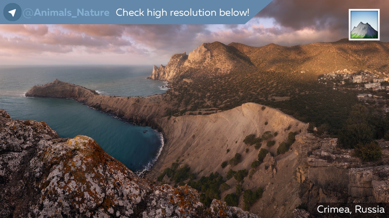
Crimea
@Animals_NatureThe Crimean Peninsula, also known simply as Crimea, is a major land mass on the northern coast of the Black Sea that is almost completely surrounded by both the Black Sea and the smaller Sea of Azov to the northeast. The peninsula is located south of the Ukrainian region of Kherson and west of the Russian region of Kuban. It is connected to Kherson Oblast by the Isthmus of Perekop and is separated from Kuban by the Strait of Kerch. The Arabat Spit is located to the northeast, a narrow strip of land that separates a system of lagoons named Sivash from the Sea of Azov.
Geography
Covering an area of 27,000 km2 (10,425 sq mi), Crimea is located on the northern coast of the Black Sea and on the western coast of the Sea of Azov, the only land border is shared with Ukraine's Kherson Oblast from the north.
The natural border between the Crimean Peninsula and the Ukrainian mainland is formed by the Sivash or "Rotten Sea", a large system of shallow lagoons. The peninsula is connected to the Kherson Oblast's Henichesk Raion, and thus the European mainland, via the Isthmus of Perekop, a strip of land about 5–7 kilometres (3.1–4.3 mi) wide, as well as by bridges over the narrow Chongar and Henichesk straits. The northern part of Arabat Spit is administratively part of Henichesk Raion in Kherson Oblast, including its two rural communities of Shchaslyvtseve and Strilkove. The eastern tip of the peninsula is the Kerch Peninsula, separated from Taman Peninsula on the Russian mainland by the Kerch Strait, which connects the Black Sea with the Sea of Azov, at a width of between 3–13 kilometres (1.9–8.1 mi).
Geographically, the peninsula is generally divided into three zones: steppe, mountains and southern coast.
Coastline
Further information: Black Sea and Sea of Azov

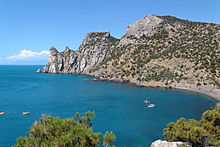
The Crimean peninsula comprises many smaller peninsulas, such as the mentioned Kerch peninsula, Heracles Peninsula, Tarkhankut Peninsula and many others. Crimea also possesses lots of headlands such as Cape Priboiny, Cape Tarkhankut, Sarych, Cape Fonar, Kazantyp, Cape Akburun, and many others.
The Crimean coastline is broken by several bays and harbors. These harbors lie west of the Isthmus of Perekop by the Bay of Karkinit; on the southwest by the open Bay of Kalamita between the port cities of Eupatoria and Sevastopol.
The Kerch Peninsula is attached to the Crimean mainland by Isthmus of Yenikale, delimited by the Bay of Arabat to the north (interrputed by the incoming Arabat Spit), and the Bay of Caffa to the south (arching eastward from the port of Feodosiya).
Crimean Mountains

The southeast coast is flanked at a distance of 8–12 kilometres (5.0–7.5 mi) from the sea by a parallel range of mountains, the Crimean Mountains. These mountains are backed by secondary parallel ranges.
The main range of these mountains shoots up with extraordinary abruptness from the deep floor of the Black Sea to an altitude of 600–1,545 metres (1,969–5,069 ft), beginning at the southwest point of the peninsula, called Cape Fiolente. It was believed that this cape was supposedly crowned with the temple of Artemis, where Iphigeneia is said to have officiated as priestess. Uchan-su, on the south slope of the mountains, is the highest waterfall in Crimea.
Hydrography
There are 257 rivers and major streams on the Crimean peninsula which are primarily fed by rainwater, with snowmelt playing a very minor role. This means there is significant annual fluctuation in water flow with many streams drying up completely during the summer. The largest rivers are the Salhir (Salğır, Салгир), the Kacha (Кача), the Alma (Альма), and the Belbek (Бельбек). Also important are the Kokozka (Kökköz or Коккозка), the Indole (Indol or Индо́л), the Chorna (Çorğun, Chernaya or Чёрная), the Derekoika (Dereköy or Дерекойка), the Karasu-Bashi (Biyuk-Karasu or Биюк-Карасу) (tributary of Salhir river), the Burulcha (Бурульча) (tributary of Salhir river), the Uchan-su, and the Ulu-Uzen’. The longest river of Crimea is the Salhir at 204 km. The Belbek has the greatest average discharge at 2.16 cubic metres per second (76 cu ft/s). The Alma and the Kacha are the second and third longest rivers.
There are more than fifty salt lakes and salt pans on the peninsula, the largest of them is Lake Sasyk (Сасык) on the southwest coast, but others include Aqtas, Koyashskoye, Kiyatskoe, Kirleutskoe, Kizil-Yar, Bakalskoe, and Donuzlav. The general trend is for the former lakes to become salt pans. Lake Syvash (Sıvaş or Сива́ш) is a system of interconnected shallow lagoons on the northern coast, which covers an area of around 2,560 km2. There are a number of dams that have created reservoirs, among the largest are the Simferopolskoye, Alminskoye, the Taygansky and the Belogorsky just south of Bilohirsk in Bilohirsk Raion. The North Crimea Canal, which transports water from the Dnieper, is the largest of the man-made irrigation channels on the peninsula.
Steppe
Main article: Pontic-Caspian steppe
Seventy-five percent of the remaining area of Crimea consists of semiarid prairie lands, a southward continuation of the Pontic-Caspian steppe, which slope gently to the northwest from the foot of the Crimean Mountains. Numerous kurgans, or burial mounds, of the ancient Scythians are scattered across the Crimean steppes.
Climate
Crimea is located between the temperate and subtropical climate belts and is characterized by warm and sunny weather. It is characterized by the diversity and presence of microclimates. The northern parts of Crimea have a moderate continental climate with short, mild winters and moderately hot dry summers. In the central and mountainous areas, the climate is transitional between the continental climate to the north and the Mediterranean climate to the south. Winters are mild at lower altitudes (in the foothills) and colder at higher altitdues. Summers are hot at lower altitudes and warm in the mountains. A subtropical, Mediterranean climate is found in the southern coastal regions, and is characterized by mild winters and moderately hot, dry summers.
The climate of Crimea is influenced by its geographic location, relief, and influences from the Black sea. The Crimean coast is shielded from cold air masses coming from north and as a result has milder winters. Maritime influences from the Black Sea are restricted to coastal areas; inside the peninsula, the influence is weak and does not play an important role. Because a high pressure system is located north of Crimea in both summer and winter, winds predominantly come from the north and northeast year-round. In winter, these winds bring in cold, dry continental air while in summer, it brings in dry and hot weather. Winds from the northwest bring warm and wet air from the Atlantic Ocean and are responsible for bringing precipitation during spring and summer. As well, winds from the southwest bring very warm and wet air from the subtropical latitudes of the Atlantic Ocean and the Mediterranean sea and are responsible for bringing precipitation during fall and winter.
Mean annual temperatures range from 10 °C (50.0 °F) in the far north (Armiansk) to 13 °C (55.4 °F) in the far south (Yalta). In the mountains, the mean annual temperature is around 5.7 °C (42.3 °F). For every 100 m (330 ft) increase in altitude, temperatures decrease by 0.65 °C (1.17 °F) while precipitation increases. In January, mean temperatures range from −3 °C (26.6 °F) in Armiansl to 4.4 °C (39.9 °F) in Myskhor. Cool season temperatures average around 7 °C (44.6 °F) and it is rare for the weather to drop below freezing except in the mountains, where there is usually snow. In July, mean temperatures range from 15.4 °C (59.7 °F) in Ai-Petri to 23.4 °C (74.1 °F) in the central parts of Crimea to 24.4 °C (75.9 °F) in Myskhor. The frost free period ranges from 160–200 days in the steppe and mountains regions to 240–260 days on the south coast.
Precipitation in Crimea varies significantly based on location; it ranges from 310 millimetres (12.2 in) in Chornomorske to 1,220 millimetres (48.0 in) at the highest altitudes in the Crimean mountains. The Crimean mountains greatly influence the amount of precipitation present in the peninsula. However, most of Crimea (88.5%) receives 300 to 500 millimetres (11.8 to 19.7 in) of precipitation per year. The plains usually receive 300 to 400 millimetres (11.8 to 15.7 in) of precipitation per year, increasing to 560 millimetres (22.0 in) in the southern coast at sea level. The western parts of the Crimean mountains receive more than 1,000 millimetres (39.4 in) of precipitation per year. Snowfall is predominant in the mountains during winter.
Most of the peninsula receives more than 2,000 sunshine hours per year; it reaches up to 2,505 sunshine hours in Karabi–Yayla in the Crimean mountains. As a result, the climate is favorable for recreation and tourism. Because of its climate and subsidized travel packages from Russian state-run companies, the southern Crimean coast has remained a popular resort for Russian tourists.
Translate:
Подробнее на Wiki ... (🇷🇺 Russian)
Leer más en Wiki ... (🇪🇸 Spanish)
ادامه مطلب در ویکیپدیا (🇮🇷 Persian)
विकी पर अधिक (🇮🇳 Hindi)
Mais sobre Wiki ... (🇵🇹 Portuguese)
Mehr zu Wiki ... (🇩🇪 Deutsch)